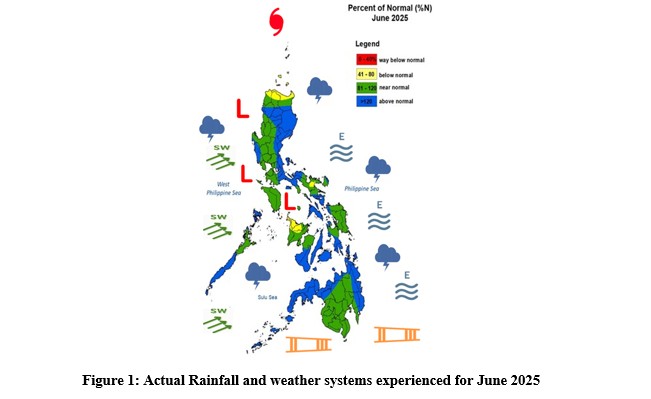
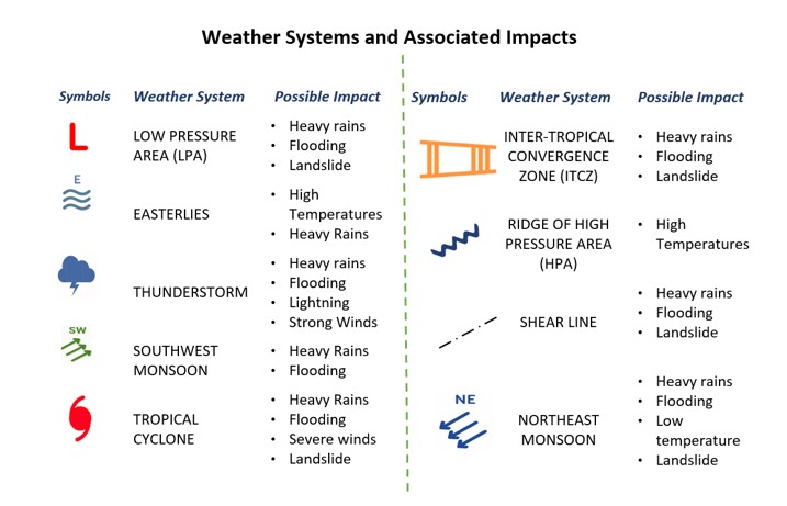
Throughout June, the country was affected by several weather systems, including the southwest monsoon, intertropical convergence zone (ITCZ), easterlies, low pressure areas (LPAs), tropical cyclone, and localized thunderstorms.
As shown in Figure 1, the entire archipelago experienced above-normal rainfall, except for some areas in the northern part of Northern Luzon, Camarines Sur, and Occidental Mindoro, which recorded below-normal rainfall.
The onset of the rainy season was officially declared on June 2 over the western sections of Luzon and Visayas, following several days of scattered to widespread rainfall caused by the Southwest Monsoon (Habagat). Despite the start of the wet season, monsoon breaks still occurred, lasting for several days or even weeks.
As of June 15, 2025, the Situation Reports from the National Disaster Risk Reduction and Management Council indicated no recorded cases of farmers or fisherfolk being directly affected by the combined effects of the southwest monsoon and Tropical Depression 'AURING' (June 12–13).
The highest recorded rainfall for the month was at Iba Synoptic Station (838.4 mm), followed by Bacnotan Agromet Station in La Union (581.3 mm), and Borongan Synoptic Station (554.2 mm).
SOIL MOISTURE CONDITION
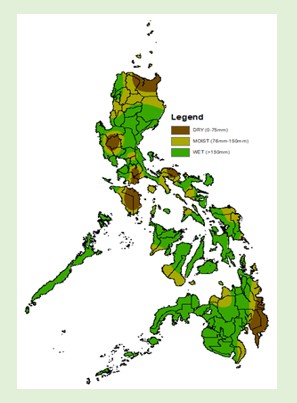
| Wet – Ilocos Region, Basco, rest of Cordillera Administrative Region, Aurora, Bataan, Olongapo City, Zambales, Nueva Ecija, Cavite, Quezon, Palawan, Camarines Norte, Albay, Catanduanes, Western Visayas, Siquijor, rest of Central Visayas, Eastern Visayas, Zamboanga Peninsula, Northern Mindanao, Davao del Norte, Surigao del Sur, and BARMM Moist – Itbayat, Calayan, Aparri, Baguio, Metro Manila, Tarlac, Mindoro Provinces, Sorsogon, Tagbilaran City, Southern Leyte, Davao del Sur, and Surigao del Norte Dry – Rest of the country TEMPERATURE |
|

| FARM OPERATIONS | |
| • Land and Seedbed Preparations • Planting and Transplanting • Weed Management • Field monitoring • Pest and diseases management • Urban gardening |
• Irrigation and Water Management • Fertilizer and Soil Nutrient Management • Harvesting • Grass-cutting, Plowing, and harrowing • Equipment and Infrastructure Maintenance • Post-Harvest Processing and Handling |
The agricultural technicians, farmers, and farm enthusiasts may continue to browse some tips and additional knowledge on potential crop production, early warning for pest and disease infestations and water management strategies for specific areas by visiting the website of Department of Agriculture in their respective regions. For daily farm weather and climate conditions, you may visit PAGASA website (https://bagong.pagasa.dost.gov.ph/)
| CROP STAGES | REGION/CROPS |
| Land and Seedbed Preparation (including preparation for garden plot, urban gardening, and upland farms), (irrigated and rainfed farms) |
|
| Planting and Transplanting (broadcasting / direct seeding – for rice, corn, conventional way/ by rows - other cash crops) |
|
| Vegetative Stage (tillering, head development) |
|
| Reproductive Stage (Heading – rice; Tasseling/Silking – corn) |
|
| Maturing/Ripening |
|
| Harvesting Stage |
|
Agroclimatic Outlook for July 2025
FARM ADVISORY
During the wet season, farmers should ensure proper drainage in their fields to prevent waterlogging that can damage crops. Use flood-tolerant or early-maturing crop varieties when necessary. Protect young plants by reinforcing seedbeds and using plastic covers during heavy rains. Time fertilizer application during dry periods to prevent leaching and wastage, and avoid overapplication. Regularly remove weeds and crop debris that can harbor pests and diseases, which thrive in moist conditions. Store harvested crops, seeds, and farm inputs in dry, covered, and elevated areas to prevent spoilage. Stay updated with localized weather forecasts and advisories from DOST-PAGASA to guide safe and timely farming decisions.
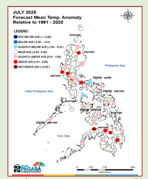
Forecast Mean Temperature Anomaly
Near to above average mean temperature conditions will be expereinced across the country, except in Romblon and Camarines Norte expecting slightly cooler than average temperatures.
ENSO ALERT SYSTEM STATUS
ENSO-neutral conditions is present in the tropical Pacific. Most climate models suggest that these conditions may continue through the December-January-February 2025-2026 season.
Extreme Temperature Range
Luzon
PAGASA will continue to closely monitor the climate conditions that may affect the country and updates shall be issued as appropriate. For further information, please contact the Climatology and Agrometeorology Division (CAD) at telephone number 8284-0800, local 4915.
For the simplified version, please download at: https://bit.ly/SimplifiedMPARO
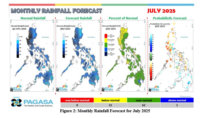
- The weather systems that will affect the country in July are the southwest (SW) monsoon, easterlies, intertropical convergence zone (ITCZ), low-pressure areas (LPAs), and localized thunderstorms.
- Two or three (2 or 3) tropical cyclones (TC) may enter or develop within the Philippine Area of Responsibility (PAR) during the month.
- As illustrated in Figure 2, near normal rainfall conditions in most of the country, except in the northwestern portion of Luzon, where below normal rainfall conditions might be experienced.
FARM ADVISORY
During the wet season, farmers should ensure proper drainage in their fields to prevent waterlogging that can damage crops. Use flood-tolerant or early-maturing crop varieties when necessary. Protect young plants by reinforcing seedbeds and using plastic covers during heavy rains. Time fertilizer application during dry periods to prevent leaching and wastage, and avoid overapplication. Regularly remove weeds and crop debris that can harbor pests and diseases, which thrive in moist conditions. Store harvested crops, seeds, and farm inputs in dry, covered, and elevated areas to prevent spoilage. Stay updated with localized weather forecasts and advisories from DOST-PAGASA to guide safe and timely farming decisions.
Forecast Mean Temperature Anomaly
Near to above average mean temperature conditions will be expereinced across the country, except in Romblon and Camarines Norte expecting slightly cooler than average temperatures.
ENSO ALERT SYSTEM STATUS
| INACTIVE (as of 03 July 2025) |
ENSO-neutral conditions is present in the tropical Pacific. Most climate models suggest that these conditions may continue through the December-January-February 2025-2026 season.
Extreme Temperature Range
Luzon
-
- Upland: 13.4 ºC – 27..0 ºC
- Lowland: 19.3 ºC – 38.4 ºC
-
- Lowland: 19.3 ºC – 36.5 ºC
-
- Upland: 15.5 ºC – 32.7ºC
- Lowland: 20.1 ºC – 36.3 ºC
PAGASA will continue to closely monitor the climate conditions that may affect the country and updates shall be issued as appropriate. For further information, please contact the Climatology and Agrometeorology Division (CAD) at telephone number 8284-0800, local 4915.
For the simplified version, please download at: https://bit.ly/SimplifiedMPARO

Prepared by: NRE
Checked by: MEVT
Approved by: TAC
Uploaded by: ARL
Checked by: MEVT
Approved by: TAC
Uploaded by: ARL